ScanMagicde ScanEX
ScanMagic es una aplicación potente y fácil de usar, que permite visualizar, analizar y procesar datos de sensores remotos (RS). En mucho casos, ScanMagic permite crear completos productos de detección remota sin haber de recurrir a herramientas adicionales. Su completa y exclusiva funcionalidad le permite procesar datos RS en prácticamente tiempo real.
 ScanMagic utilizes efficient innovative techniques of image processing. On-the-fly spooling allow to open images of up to 4 GB in size instantly and provides analyzing that large data volume in real-time viewing mode. On-the-fly processing (for example, image re-projection on–the-fly) allow to change data processing parameters repeatedly and visual estimating of the result in real-time. ScanMagic utilizes efficient innovative techniques of image processing. On-the-fly spooling allow to open images of up to 4 GB in size instantly and provides analyzing that large data volume in real-time viewing mode. On-the-fly processing (for example, image re-projection on–the-fly) allow to change data processing parameters repeatedly and visual estimating of the result in real-time.
Features
Graphical User Interface (GUI)
- Windows based multi-document user interface
- An all-in-one package with easy-to-use interface
- Well balanced, operative and intuitive software
- Familiar and configurable GUI
- Setting preferences
Import Images
- Importing more than 60 generic/GIS/RS image formats
- Image type auto detecting while importing
- Direct access to any raster data formats without conversion
- Immediate opening images independently from their size
- Opening many images at once without memory overflow
- Supporting generic RAW binary format with manual definition
- Recent list of files accessed
Export Images
- Image exporting to many generic/GIS/RS image formats
- Supporting export to COTS GIS and RS packages, including ESRI, ENVI, ERDAS, PCI, ERMAPPER, etc
- Exporting compressed data formats (e.g. JPEG2000, ECW)
- Supporting spatial and spectral subset while exporting images
- Exporting images with custom histogram stretching
- Generating Quick Look and Meta Data files
Print Images
- Common tools for preparing and printing images
- Adjusting printer and page parameters
- Header and Footer editing
- Print preview
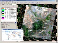
Image Manager
- User-friendly file manipulation tool for intuitive browsing and product selection
- Attribute-based and list-form review of images from disc
- Viewing image location on the world map
- Customize reference map and projection
- Display selected images and image selection on a map
- Direct opening images from list or map
- Handy choosing and deleting images from disc
Image Analysis
- Getting image information
- Measurement tools in real-time cursor movement
- Planar coordinates and pixel value displaying in real-time
- Real-time geographic and cartographic coordinates displaying
- Real-time sun azimuth and elevation calculation for any pixel
- Displaying parameters of selected fragment
- Measuring distances
Image Vizualization
- Real-time displaying images of size up to 4 GB with radiometric resolution up to 16 bit
- RGB color composite viewing
- Grayscale channel-by-channel viewing
- Pseudo color viewing and color table editing
- Easy image zooming and scrolling
- Zoom In/Out/ToWidth/ToHeight/Actual/Rectangle
- Supporting Undo (Previous Zoom command)
- Handy Zoom Bar for easy changing the zoom level
- Effective Pan mode (free image scroll by mouse drag)
- Flexible Navigate tool (scroll/zoom window)
- Automatic path along scrolling
Image Enhancement
- Contrast/Brightness enhancement
- Quick Enhance (Easy Contrast)
- Graphical histogram contrast adjustment tool
- Linear and nonlinear contrast enhancement
- Min-max linear contrast stretch
- Percentage linear contrast stretch
- Histogram equalization
- On-the-fly algorithms of image processing
- Spatial enhancement (e.g. noise filtering)
- Satellite instrument processing
- Generation of value added products.
- Resolution Merge (Image Fusion) with Brovey, HLS and Arithmetic Transformation methods.
- Merging Radar with VIS/IR Imagery
- Satellite based specific radiometric correction
Overlaying Vector Maps
- Fast overlaying vector data on image
- Extra speed while overlaying ESRI DCW data
- Supporting prevalent vector formats, including ArcInfo Coverage, ESRI Shapefile, MapInfo MIF/MID, MapInfo TAB, Microstation DGN
- Multiple-vector overlaying
- On-the-fly map re-projection
- Supporting points, lines and polygons
- Customizing size and color of vector objects
- Point-and-click getting attributes of map objects
Geographic Location
- Automatic geographic and cartographic location of RS and GIS images while opening
- Supporting georeference file formats (e.g. ESRI World File, MapInfo Tab File, WKT)
- Universal Orbit/Sensor Model for easy georeferencing of remote sensing images from any generic format
- Manual georeferencing for any raster data
- Satellite trajectory information extraction from NORAD TLE files
- Easy adjustment for satellite position and orientation
- Ground Control Points (GCP) rectification
- Graphical selection of GCPs with automatic coordinate conversion
- GCP editor with import and export capability
Geometric correction
- On-the-fly technology using while geometric correction
- Image transformation into user-defined map projection
- Over 70 map projections, 40 ellipsoids and 200 datums
- Over 2000 prepared EPSG coordinate systems
- User-defined projections, coordinate systems, ellipsoids and datums.
- ROI selection
- Image-to-map and image-to-image rectification
- On-the-fly image re-projection
- Affine and Polynomial (up to 5th) transformation
- Image resampling to coordinate system: Nearest Neighbor, Bilinear, Cubic Convolution
- User-defined pixel size and geographic subset
- Up to 255 channels for output cartographic product
- GCP selection from image, vector map and user input
- Any spatial and spectral image mosaicking
- Image mosaicking with manual color balancing
|